Trail Map and Directions
Stickney Hill Road/Millstone Drive
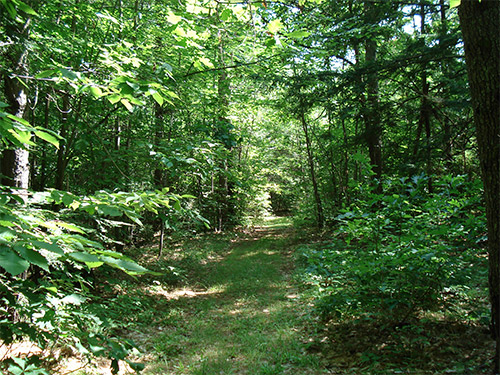
24 acres of pine, oak, and hemlock forest
Public access
December 2019
Thomas M. Armstrong and his family donated the 24-acre Armstrong Forest Preserve to Five Rivers Conservation Trust. Mr. Armstrong entrusted the forestland to Five Rivers with these words, “encourage active public observation, learning and enjoyment…for the study and wonder of nature, forests in particular, outdoor recreation, and the recharging of our minds, bodies and spirits.”
Located on Stickney Hill Road, the Preserve enhances, connects, and is in close proximity to St Paul’s School land and conserved land. Land to the east, is owned by St. Paul’s School. City of Concord land and the West End Farm Trail extend to the north. Three expansive fields and farms conserved by Five Rivers Conservation Trust lie to the west. If you want to visit the Preserve, it is directly across Stickney Hill Road from the botttom of the Exit 3 ramp from I-89 North.
Towering white pines and oaks cloak the new Preserve. Perimeter trails beckon walkers, runners and cross-country skiers to explore this lesser known, less crowded part of Concord.
The Armstrong Forest Preserve is a gateway to an inviting trail network of scenic discontinued town roads along the southern boundary of the property. The trail begins on Millstone Drive, passes the historic Stickney Cemetery and connects to NH Snowmobile Corridor 11.
If you want to explore the untrailed interior, you may find the vernal pool in spring and a small forested wetland. The forest has not been harvested in over 40 years and is maturing into venerable pines, oaks, and hemlocks. In winter, explore on snowshoes to learn which critters leave tracks in the snow. At other times of the year, step gently and you will discover hidden wildflowers, mosses and ferns.
Tom Armstrong, now of Scarborough, Maine, purchased this forestland in 1953, after he worked at Fox State Forest in Hillsborough. He donated the Preserve to Five Rivers in memory of his wife, Rachel Franck Armstrong, and in honor of his forestry mentors and friends Henry Ives and Birgit Baldwin, and Frances and Larry Rathbun.
130 Hutchinson Road
120 acres of forest
Public access, hiking trails
March, 2018
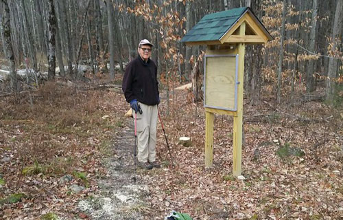
Five Rivers and the Town of Chichester teamed up to enhance the level of conservation for the Chichester (Spaulding) Town Forest in March 2018, Five Rivers’ first property conserved by easement in Chichester! This 120-acre working forest is located on the Chichester/Pembroke Town Line, off of Hutchinson Road in the southern part of Town. The easement adds to the Town’s other easement holdings which total nearly 400 acres.
The Town has owned most of the Town Forest parcel since the 1950s, and has carefully managed it under the professional guidance of licensed forester Charlie Moreno. Forest Management has improved the quality of the forest overall and is encouraging future growth on the best quality trees on the property. In addition to sustainable forestry, the Town’s forest management goals include preservation of wildlife habitat and promotion of passive recreation.
NH Fish and Game ranks this property among the best wildlife habitat in the state, and includes habitat suitable for creatures ranging from large mammals to amphibians. The property abuts the Humphrey Forest, conserved by the Society for the Protection of NH Forests. These properties, plus other nearby conserved land, provide over 400 acres permanently protected for wildlife to roam. Additional unprotected open spaces create a contiguous block of 1300 acres.
The property is open to the public and currently has three trails of varying length and difficulty. The highest terrain on the parcel provides some exceptional views to the east.
Many New Hampshire towns have designated Town Forests, and some people believe that these properties are conserved by that designation. However, the Town Forest designation can be removed by a vote at town meeting. The Chichester Town Forest is protected by a conservation easement, which limits its use to forestry, outdoor recreation, wildlife habitat management and conservation – forever.
Five Rivers will continue to work with the Town and the Conservation Commission to ensure that the property’s conservation values are always protected for the public benefit.
Trail Map
Dustin Road
35.8 acres of forests, wetlands, and farmland
Public access
November 2014
The D&B Dustin easement is almost completely forested. One area near the road was most recently pasture and is now a nearly pure stand of white pine. Most of the property is upland forest consisting of a mixture of scattered larger white pines with some red oak above an understory of smaller oak, red maple, beech and birch. There is a flood plain forest near the river consisting of silver maple with some elm and abundant shrubs. There is a hemlock stand near the stream.
The property has outstanding wildlife habitat value due to its varied habitats and proximity to the river. The NH Wildlife Action Plan shows this property as abutting and supporting some of the highest ranked habitats in the region.
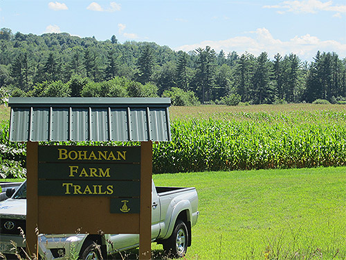
Wetland areas are near the river and include over 1,600 feet of frontage on the Contoocook River. The property has over 825 feet of scenic frontage along Dustin Road. Trails connect to the Bohanan Farm Trail network.
Bohanan Farm has been in existence since Lester Bohanan bought the land in 1907. From the 1930s on, the farm became primarily a dairy farm and has grown with every new generation. Lester’s great-grand-daughter, Heather, married Jaime Robertson, who currently manages the over 400-cow operation.
In 2008 the family decided the best way to ensure the land remained unaltered for future generations was to place an easement on it. However the cost to do so was quite substantial and Jaime asked the Town of Hopkinton if they were interested in purchasing the development rights. Hopkinton’s Open Space Committee began building support for the idea among the voters while Five Rivers got involved and raised money through state and federal grants as well as generous private donations. The State of NH and the National Resource Conservation Service through its Farm and Ranch Lands Protection Program also provided valuable assistance.
In the largest town meeting in the town’s history, Hopkinton residents overwhelmingly voted to preserve the farm. After the land was under easement, Jaime decided to widen the scope of the farm. He created the Contoocook Creamery and you can find their milk in traditional glass bottles in many local grocery stores. The Robertsons also sell eggs and have started raising cattle for beef, not just milking. Blueberry and raspberry patches are also in the works and should be ready for the public in a couple of seasons. Logging has always brought in extra income for the farm but is done in a sustainable manner. There are large cornfields on the property that produce about 50% of the cow’s feed over the course of the year.
For years there have been trails on the property that were open to the public but now that Hopkinton maintains them, there is a designated parking area and they are clearly mapped and marked. Click here to access the Hopkinton Conservation Land website, which includes a full description of all Bohanan Farm trails and access to trail maps.
The Courser Hill Loop trail is a 2.3 mi round trip and starts from the parking area. It heads along the Contoocook River past a canoe and kayak launch, around a field and then cuts inwards towards Courser Hill. Once in the woods the trail divides into the loop portion. The trail has a long stretch through the woods and another sizeable stretch that cuts through Courser Hill pasture and over the top of the hill. At the top of the field there is a small grove of trees with an old cellar hole at the center. You should be aware that at certain times of the year there may be cows grazing in the pasture.
Across the road from the main farm, along Burrage Road, there is the 1.5 mi Blackwater River Loop trail. It cuts in past a cornfield and leads into the woods. There is a lookout point over the Blackwater River on the north-west part of the trail. The path also leads past several vernal pools. This trail is ideal for cross-country skiing and biking in addition to being a nice walking route.
The newly added Contoocook Overlook Trail (conserved by the Town of Hopkinton and owner Donelda Horne and not Five Rivers) leaves the Blackwater River Loop at the half way point, adding ¾ of a mile to the Blackwater Loop (2.2 miles total with the overlook trail). The trail follows a bluff above the Blackwater River before turning toward the Contoocook River where an overlook provides beautiful views where the two rivers converge. The trail climbs a short hill to a bluff along the Contoocook River, follows through mature woodlands with views over Bohanan fields, and rejoins the Blackwater River Loop. Click here to access the Hopkinton Conservation Land website, which includes a full description of the Contoocook Overlook Trail and access to trail maps.
After your hike, don’t forget to say hello to the cows. They’ll appreciate it.
In 2009, this scenic 85-acre city park astride one of Concord’s highest hills was created in honor of former New Hampshire Governor John Winant and his wife Constance. The park is a gift to the City of Concord from the late governor’s son, Rivington Winant, and his wife Joan. The transfer and conservation of the property was made possible through collaboration among the Winants, the City, St. Paul’s School, and Five Rivers Conservation Trust.
The City owns and manages the public park, subject to a conservation easement held by Five Rivers Conservation Trust that ensures the property will be protected in perpetuity. Rivington and Joan Winant generously donated the conservation easement to Five Rivers and then conveyed their property ownership to the City. St. Paul’s School, through a separate easement conveyed to the City with an executory interest to Five Rivers, graciously allowed construction of a parking area, trailhead, and an access trail from land the school owns along Fisk Road to the landlocked Winant property.
Former Governor Winant attended, taught at, and is buried at St. Paul’s School and served for three terms as Governor of the State. He cared deeply for both, noted his son Rivington Winant in announcing the gift to the City, and with views of both the school and the capitol, it serves as a fitting memorial.
Rivington Winant grew up on the Winant property near what is now Concord Hospital. The 85 acres is the remnant of a larger estate on Pleasant Street. The land encompassed by the new park is dominated by pine-oak forests, and includes the former estate’s bridle trails. Over the years, nearby residents have privately maintained and used the property’s extensive trail network for hiking, cross-country skiing, and mountain biking.
Construction of an official park entrance on St. Paul’s land off Fisk Road included an off-road parking area, a foot bridge across Miller’s Brook, and an informational kiosk recounting the history of the park and a biography of Governor Winant. The Unitarian Universalist Church, located on Pleasant Street, also kindly provides user access through its driveway across an existing right-of-way.
As set forth in the conservation easement developed by the parties, the park is intended solely for non-motorized recreational uses such as hiking, skiing, and bicycling. The intent of the gift is to preserve the wild nature and native habitat of the park; no park buildings, sport facilities, or other formalized structures or fields will ever be built there.
In addition to the land gift and easements, Mr. and Mrs. Winant generously funded the initial construction costs for the parking lot and clearing the trails, the kiosk, and trailside benches. The city assumes responsibility for maintaining trails and the parking area, and for other park management. Five Rivers has responsibility for monitoring and enforcing the terms of the two easements.
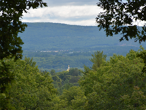
Winant Park provides a special open space resource for Concord, with its forested lands, trails, and open summit with views of Concord and distant countryside. It is an island of peacefulness, located right in the heart of our state’s capital city, enriching the fabric of this community.
A Brief Biography of John Winant
John Gilbert Winant was born in New York in 1889 and attended St. Paul’s School, graduating in 1908. He attended Princeton and returned to St. Paul’s, where he taught history. He left to serve in World War I, then returned to St. Paul’s to teach. While there, he became interested in politics, served in the State Legislature, and in 1925 became the country’s youngest governor.
After Winant completed his governorship, President Franklin Delano Roosevelt appointed him as the first chairman of the Social Security Board. In 1937 Roosevelt asked Winant to go to Geneva as the senior US member of the International Labor Organization, of which Winant later became director-general.
As World War II loomed, Roosevelt appointed Winant as the American ambassador to the Court of St. James in London. Winant and Prime Minister Winston Churchill became close friends. On Sunday, Dec. 7, 1941, Winant was in the room when Churchill turned on the radio and heard that the Japanese had attacked Pearl Harbor.
Throughout the war, Winant frequently traveled throughout England and is still remembered for his likeable and reassuring nature. He was presented with the ceremonial keys to a number of English cities, and at the end of the war King George VI presented him with the Order of Merit, Great Britain’s highest civilian honor.
After the war, Winant retired to Concord to write his memoirs. He is buried in St. Paul’s School cemetery off Hopkinton Road.
For many years John and Marjory Swope lived on Long Pond Road and the area that was their backyard is now the park. Back then there were a few woods roads and rough trails that the family and their neighbors frequently used for walking, jogging, and cross-country skiing. When Marjory passed away in 2007, John decided to donate the land to the City of Concord to create a place that people could enjoy as a memorial to her. Marjory was a long time member of the City Council and served as the chair of the Concord Conservation Commission. The city welcomed the offer.
John Swope entrusted the easement of the park to Five Rivers to ensure that the land would be properly maintained. The park was dedicated and “officially” opened in June 2012.
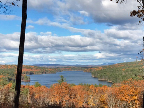
The City of Concord worked with the Swope family, Five Rivers, and St. Paul’s School to create the park that can be visited today. There are three connecting trails that are open for non-motorized recreation such as walking and biking. There is a loop trail (1.45mi) up Jerry Hill, marked in blue, leading to one of the best views of Penacook Lake. The yellow trail (0.56mi) cuts through the park from north to south and goes past the foundation of an old observation tower. From the center of the yellow trail cutting west to the blue trail is the orange trail (0.18mi) that will take you past a large granite outcrop called Gilfillan Rock.
Marjory Swope Park serves as the gateway to an already considerable area of land conserved by the State, City of Concord, Society for the Protection of NH Forests, St. Paul’s School, and Rossview Farm. There is a plan to someday connect these properties to create many miles of uninterrupted hiking. John hopes that as people walk through the park, they appreciate the uniqueness of our state capital — to be able to enjoy a downtown with restaurants and a movie theater and, not five miles away, find trails to get out and explore the natural world.
Dimond Hill Farm is one of the premier farm landscapes in the region. A working farm since the late 1700s, it consists of large open fields, both north and south of Hopkinton Road in Concord. Sitting atop a sloping hillside, the farm has panoramic views, and it serves as a visual milestone for travelers entering and leaving the city.
Under special conservation easements signed in June of 2006, the farm will remain a working farm, with Equity Trust serving as the owner and NH Preservation Alliance serving as the Historic Easement holder for the farm buildings.
Five Rivers Conservation Trust holds conservation easements for both the 74.8 acre Farm Easement portion and the 34.3 acre Forest Easement portion of the property.
The farm consists of open fields, an historic barn, and several greenhouses. Located on the Farm Easement is a wetland with nesting ducks, as well as a hidden, very-attractive field of wildflowers near the south border. On the north side of Hopkinton Road are pastures, a clearing with nice views, and forests of pine.
Also on the north side is the property’s 34-acre Forest Easement. It consists of a mixed hardwoods and softwoods, graced by a huge old ash tree near one of the property’s many stone walls. Traversing this Forest Easement section is Ash Brook, a hemlock-lined stream that tumbles its way downhill. A unique structure is an old ice pond dam of granite slabs, a structure used to collect ice in the winters which was sawed, stored under sawdust in a barn, and used during the summers.
Traversing the entire property is an attractive trail used by walkers, snowmobilers, skiers, and horseback riders. A variety of wildlife abound throughout this interesting property, including deer, fox, and many species of birds.
The former owners of Sunnycrest Orchard also owned an orchard in Londonderry, and they needed to consolidate their operation. Rob Larocque, who had managed the orchard for many years decided he wanted to own it. Through a collaboration between Five Rivers Conservation Trust, the City of Concord, the Friends of the Orchard, the Trust for Public Lands, the NH Land and Community Heritage Investment Program (LCHIP), and the Federal Farmland Protection Program, this 155 acre property and its agricultural, forestry and recreational resources was preserved.
The orchard project exemplifies the goal of protecting not only open space but a quality of life that is rapidly disappearing. From picking berries in the spring and apples in the fall, to skiing the trails in the winter, to taking in the spectacular views from the top of the hill, the orchard offers something for everyone throughout the year.
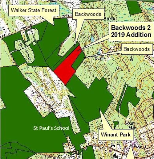
The Backwoods Preserve is a landlocked 54 acres that abuts Walker State Forest and Winant Park in Concord, NH. A ridge runs through the land making it unsuitable for building houses but the terrain does make for excellent wildlife habitat. Moose, deer, bear and coyote use this land as part of their territories.
Backwoods 1 (28 acres)
In 2002 a group of neighbors (the Backwoods Group) began the process to preserve this open space which is ideal for low impact recreational uses such as hiking, cross country skiing and mountain biking.
In 2003, with donations raised by the Backwoods Group along with funds from the City of Concord’s land use change tax fund, the property title was acquired by the city of Concord and the easement was placed on the land.
Backwoods 2 (26 acres)
“Backwoods 2” is a 26-acre addition to the original Backwoods property of 28 acres. This latest addition was purchased by the city in September 2019, who donated a conservation easement on the property to Five Rivers Conservation Trust.
This property is the missing piece, connecting Five Rivers-conserved Winant Park to Walker State Forest, creating nearly 200 acres of contiguous conserved land behind Concord Hospital and the Unitarian Universalist Church. Winant Park and Walker State Forest have been connected for years by a network of trails used by hikers and bikers, but there was no guarantee of continued access under private ownership. Now, thanks to the City’s foresight and commitment to conservation, this property will remain open to the public.
Trail Map Briar Hill Road and Route 103
Two parcels totaling 68.5 acres of fields, forests, and brook
Public access
October 2006
The 68-acre Ransmeier Woods property has two trails, offering both a field and woodland hiking experience within just a short drive of Hopkinton Village. The shorter trail circles a large hayfield and passes Smith Brook near an old dam. The longer trail continues through a mature woodland with views of the brook at the base of a steep ravine. The Ransmeier Woods trails connect to the Hopkinton Village Greenway from the longer loop trail.
Both trails start at the Police Station, skirting the right hand edge of the hayfield, then entering the woods and following Smith Brook along the edge of the woods close to the field. The trail passes near a now-broken dam/road across the brook that once provided access for farm vehicles. Shortly before a footbridge, the orange trail turns uphill to the left and returns to the field, circling the edge of the field back to the parking area. The Blue trail continues across the footbridge, with nice views of the brook, especially at times of high water, passing through mixed woodlands with some steeper pitches, crossing through some old stone walls and returning back to the bridge.
Trail Map
100 acres of mixed forest, streams, and wetlands
Public access
November 2003 & February 2026
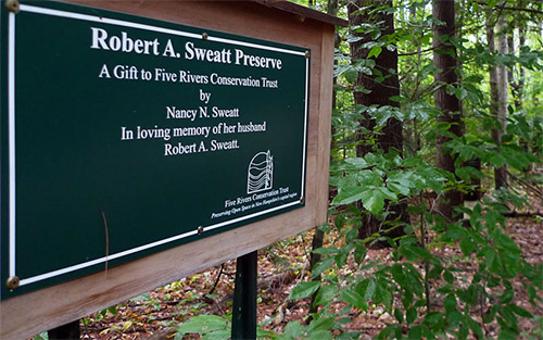
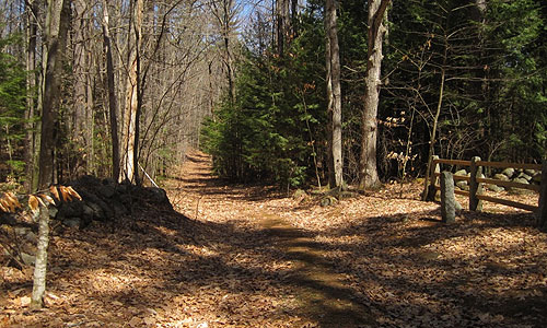
The Sweatt Preserve Nature Trail is located alongside Old Stagecoach Road near Hopkinton Village, a dirt road that rises from Briar Hill Road up to Gould Hill. Consisting of a 2-mile pathway marked by a roadside sign, the trail leads hikers and snowshoers deep into the forest, over brooks, up a slight hill, around a loop, and back to the start. Nature trail brochures are available at the trailhead, providing an overview of the property’s history and natural features.
This woodland trail is a great one for kids, with its two footbridges over a brook, hidden away in a hemlock grove at the bottom of a steep ravine. After the stream and a short climb, the trail loops back through thinly wooded former pasture land edged with stone walls.
The Sweatt Preserve was generously given to Five Rivers Conservation Trust in 2003 by Nancy N. Sweatt in loving memory of her husband, Robert A. Sweatt. Robert was a decorated veteran of World War II. During his many years in the service, he lived in various locations around the globe. His love for his boyhood town of Hopkinton and his land on Old Stagecoach Road never diminished. He and his wife were committed to preserving this land as a preserve for all to enjoy. The trail was built and maintained by volunteers from Five Rivers Conservation Trust.
To enhance protections for the streams and wetlands on the property, Five Rivers purchased the abutting upland property of 28 acres from Tim Sweatt and his brother-in-law Stan Pastuszczak in February 2026. With the Sweatt Headwaters Addition, the expanded preserve is nearly 100 acres.
The Five Rivers
The Merrimack, Contoocook, Blackwater, Warner and Soucook Rivers converge in an area of river bottom farmland and rolling hills that defines Five Rivers’ service area.

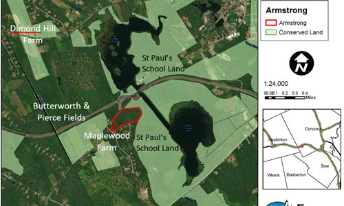
 130 Hutchinson Road